For many years, governments and operators have used helicopters, ground patrols, and satellites to keep an eye on large areas. A new generation of long-range drones promises to fill in the expensive gaps between those tools. A major player in French aviation is working quickly to get a certified system in place by 2025.
From a test device to a workhorse for the area
For a lot of people, the word “drone” still brings to mind a buzzing quadcopter that films weddings or construction sites. The machines that Thales is interested in are in a very different group. They are made to fly far beyond what the pilot can see, stay in the air for a long time, and do the same mission over and over again.
These long-range platforms, which are often called BVLOS (Beyond Visual Line Of Sight), are designed for real-world tasks like mapping large areas, protecting important infrastructure, watching borders and coastlines, keeping an eye on the environment, and helping with search and rescue.

They don’t replace satellites, planes, or helicopters; instead, they connect those abilities and fill in the gaps that no one else can afford to fill all the time.

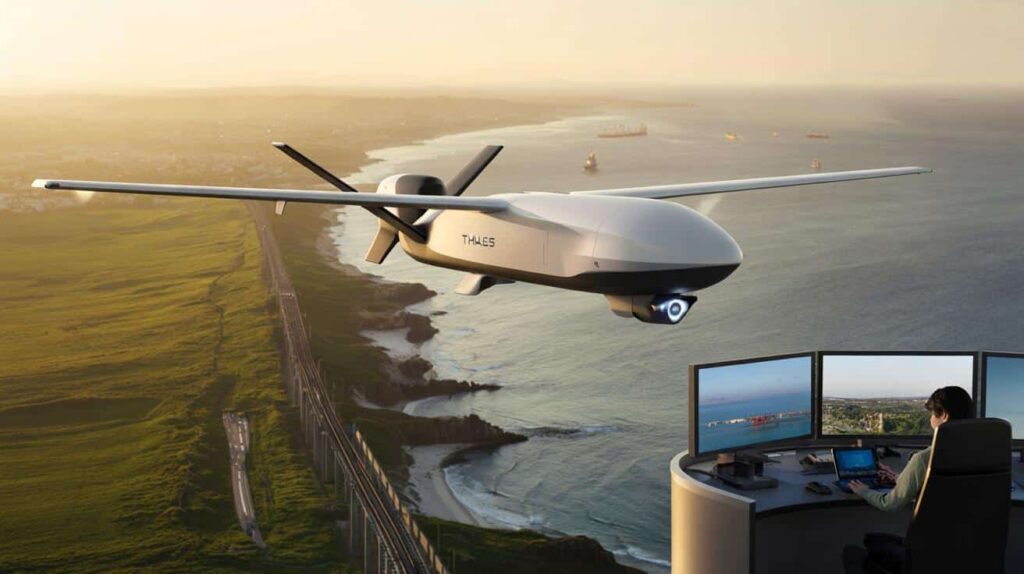
Thales markets its UAS100 in this area as a kind of tireless scout. It’s not flashy or loud, but it can cover hundreds of kilometres and send useful, repeatable data to operators on the ground.
Autonomy, not just fuel, is the main technical problem.
Autonomy is more about brains than fuel tanks for long-range drones. The farther a drone flies from its operator, the more it has to handle both planned and unplanned events on its own.
European regulators now require that any such drone act in a way that is easy to understand and predict. It should be possible to find out where every automatic action came from. You need to plan for every possible outcome ahead of time. If the radio link goes down, the plane still needs to stay away from no-fly zones, stay at safe altitudes, and follow a set plan for returning or landing.
Regulators see these planes more like small airliners that fly without a pilot than like gadgets.
This method makes it necessary for manufacturers to create avionics and flight-control software that are very similar to those used in certified aviation. Thales thinks it can beat younger drone-only competitors there because it has decades of experience in the cockpit and with air traffic.
A European regulatory framework that sets higher standards
The time when anyone could fly drones is coming to an end. The European Union Aviation Safety Agency (EASA) has had a structured framework for unmanned aircraft in place since 2019. This framework includes system certification, operator training, maintenance, and risk management.
The Specific Operations Risk Assessment method, or SORA, is one of the most important tools. It makes operators look at both ground risk (who or what is under the flight path) and air risk (what other planes might be nearby), and then match technical and procedural safeguards to the level of risk.
Drones and basic procedures are fine for low-risk operations.
Flights with a medium risk need better communication, geo-fencing, and training for pilots.
Aircraft that are close to traditional aviation standards are needed for high-risk missions.
Long-range drones, like the UAS100, are usually at the top of that range. They might fly over important infrastructure, share airspace with planes with people on board, or cross national borders. For Thales, this means not only building an airframe, but also an entire ecosystem that meets aviation standards.
UAS100 is more than just an airframe; it’s a system.
Thales calls the UAS100 a family of fixed-wing drones with hybrid propulsion that can fly in a straight line for 200 to 600 kilometres, depending on the version. A small model with a wingspan of 3.3 meters is already flying test flights, and a bigger model with a wingspan of 6.7 meters is getting ready for its first flights.
The company wants to get full certification by the end of 2025, which will make the system ready for civil and “dual use” operations in Europe and beyond.
Feature: Description of UAS100
| Setting up | Fixed wing with a mix of propulsion |
|---|---|
| The distance between the wings | 3.3 m (for the current tests) and 6.7 m (for the larger version) |
| Operational range | 200 to 600 km along a straight track |
| Crew on the ground | A single supervisor at a dedicated ground station |
| Data management | Safe private cloud for storage and processing |
| Target missions | Coastline and border surveillance, help for law enforcement, and checking linear infrastructure |
Thales uses avionics technology from certified manned aircraft that has been modified and made lighter for use in unmanned aircraft. The drone is meant to work from small areas and be very automated, doing things like safety checks before flight, navigation, and backup plans.
One of the most important selling points is that it can withstand jamming and complicated electromagnetic environments. This is a concern that has moved from the military to civil security planning.
A single person is in charge of the ground station that goes with it. Software takes care of things like checking the weather, making sure temporary restricted zones are safe, and running automatic system health checks. This structure keeps costs down for workers while keeping the operator and the machine in close contact.
Concrete missions: from pipelines to routes for migrants
Thales doesn’t market the UAS100 as a showpiece for airshows. The focus is on missions that are repetitive and often boring, but that are still very important to national and industrial customers.

- Checking a lot of infrastructure
- Watching the coast and the border
- Monitoring the environment and keeping people safe
Energy companies, rail operators, and power grid managers all have the same problem: they have to keep an eye on thousands of kilometres of assets. Helicopter inspections that are done the old-fashioned way are expensive and depend on the weather. Ground patrols are slow and not always the same.
Long-range drones, for example, can follow a gas pipeline for hundreds of kilometres, flag any leaks, intrusions, or ground movement that they see, and send that information to maintenance systems almost in real time.
A UAS100 can patrol fishing areas, shipping lanes, or migrant routes along the coast and send electro-optical and infrared images to command centers. It doesn’t take the place of maritime patrol aircraft, but it can keep an eye on things between crewed flights, especially at night or in medium sea states.
For land borders, the same pattern holds: the drone follows a set path, checks events picked up by ground sensors, and helps guide patrol teams to the places where they are most needed.
A long-range drone can help civil protection by giving them early warning of wildfires, floods, or industrial accidents. It can map smoke plumes, follow the path of a flood, or check the damage to transmission lines after a storm if it has the right payloads.
Environmental agencies may use the same platform to keep an eye on coastal erosion, illegal dumping, or deforestation over large areas—things that satellites alone can’t do often enough or in enough detail.
A market that is getting bigger because of rules and size
Analysts think that the market for drone inspections and monitoring will grow quickly, going from about $15.2 billion in 2025 to about $61.5 billion in 2035. Long-range systems make up only a small part of that number, but they are in some of the most difficult and profitable niches.
Tighter rules and economic forecasts work together to help businesses that already know how to talk to aviation authorities.
The EASA framework pushes the industry in Europe toward systems that are more mature, documented, and certifiable. That trend makes it harder for very small newcomers to get in once operations move out of the low-risk hobby or local mapping area. Big aerospace companies like Thales and smaller, more specialised companies are likely to take over high-end BVLOS missions.
The main competitors in long-range civil drones
| Business / system setup | Main segment |
|---|---|
| Thales—UAS100 | Fixed-wing, hybrid propulsion Long-range monitoring and inspection |
| TEKEVER – AR5 | Light MALE fixed wing: maritime patrol and long-range surveillance |
| Schiebel’s Camcopter S-100 | VTOL with a rotary wing Surveillance from ships and along the coast |
| Quantum Systems – Trinity series | eVTOL with fixed wings Mapping and collecting data over large areas |
| Wingtra – WingtraOne Gen II | VTOL fixed wing Mapping for construction and mining with high accuracy |
| Delair – UX11 | Fixed Wing Survey and check over large areas |
There are trade-offs between endurance, payload weight, take-off space, and complexity on each platform. The UAS100 bets on fixed-wing efficiency and hybrid propulsion, accepting runway-like launch sites in exchange for long linear coverage.
Important ideas and how they work in real life
Some technical terms can be hard to understand for people who aren’t experts. BVLOS and SORA are two things that affect almost every decision in this market.
When a drone flies BVLOS, the operator can’t see it directly. Instead, they rely on instruments, telemetry and imagery on their screen. This sounds ordinary in aviation, but with drones it triggers stricter rules, because the pilot cannot visually spot other aircraft or unplanned obstacles. Systems must make up for this with geo-fencing, detect-and-avoid technology, reliable communication links, and planned emergency routes.
SORA, the risk assessment method, acts like a checklist that regulators and operators share. For example, they look at whether the drone could fly over a lot of houses, whether it would cross controlled airspace near airports, and what kinds of emergency landing sites are along the way. Each risk drives technical requirements, from parachutes to redundancy in navigation sensors.
Possible situations, advantages, and questions that are still open
Imagine a winter storm that knocks out power lines in a part of Europe. Crews need to know which pylons fell, which access roads are blocked, and where to send heavy vehicles. A long-range drone such as the UAS100 can fly pre‑programmed corridors along the grid, stream high‑resolution video and thermal data, and build a live map of damaged segments. Helicopters then focus only on the worst areas, and ground teams avoid wasted trips.
Or take a maritime safety scenario. During peak summer traffic, coastguards struggle to cover both tourist zones and busy shipping lanes. A BVLOS drone can run repeated arcs along the coast, automatically flagging small boats drifting off course, and keep a watch over offshore wind farms or oil terminals at the same time.
These capabilities bring clear benefits: lower per‑hour costs than helicopters, reduced risk to human crews, and more consistent data. They also introduce new questions: cybersecurity of the control links, noise and privacy for coastal communities, and dependence on complex software whose failures may be hard to predict.
The shift is not only technological; it is organisational. Agencies must rethink training, maintenance and data governance when a “single pilot” can patrol an entire border from a control room.

As 2025 approaches, the race is less about flying prototypes and more about obtaining the right stamps from aviation authorities. If Thales secures certification on schedule, the UAS100 could rapidly move from trade‑show model to a quiet, persistent presence above Europe’s most sensitive arteries.